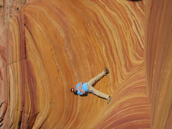
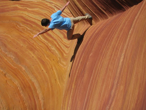
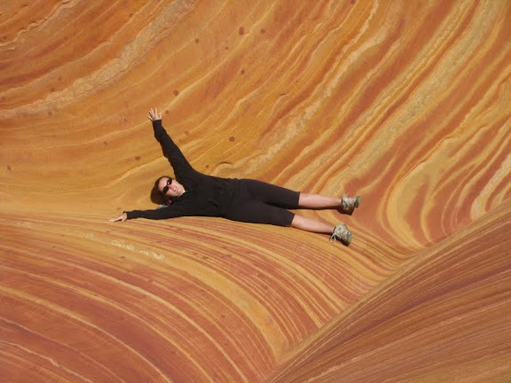
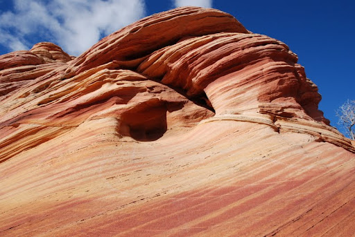
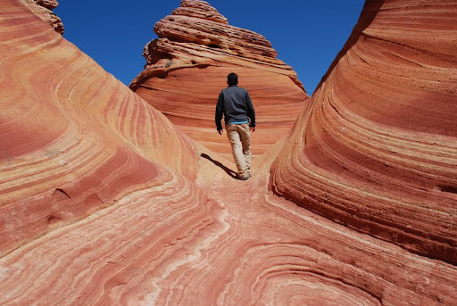
The Wave is a sandstone rock formation located in the United States of America near the Arizona and Utah border on the slopes of the Coyote B uttes, in the Paria Canyon-Vermilion Cliffs Wilderness, on the Colorado Plateau. It is famous among hikers and photographers for its colorful, undulating forms, and the rugged, trackless hike required to reach it.
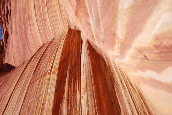
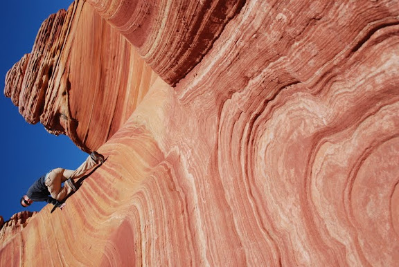
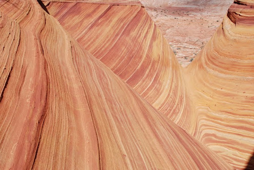
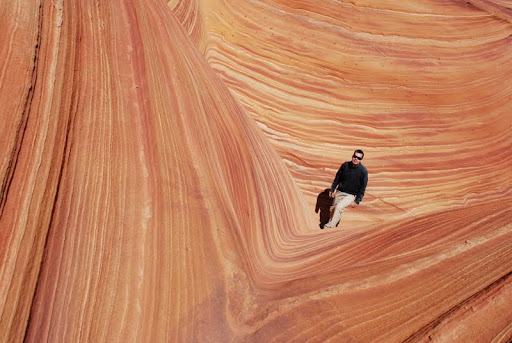
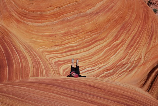
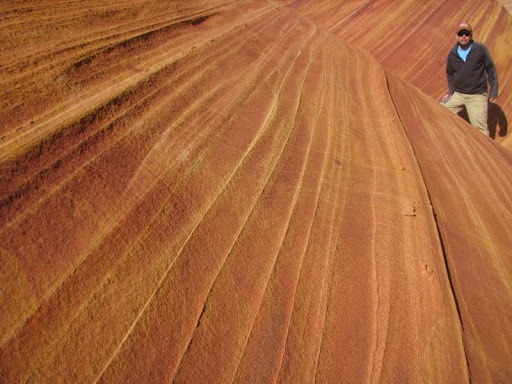
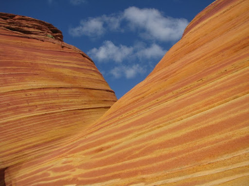
The Jurassic Navajo Sandstone Formation is the foundation of Coyote Buttes (and the Wave), Nearly 200 million years ago, this region was a sandy desert where huge dunes migrated across the landscape pushed by seasonal winds. Prevailing winds of that ancient Jurassic time can be determined by examining the cross-bedding (layers) in the sandstone. What we see today are some of the original crossbedded dunes shaped into dramatic landforms and exposed by erosion from eons of runoff. The spectacular ribbons of various colors called Liesegang Bands, were formed by movement and precipitation of oxidizing materials such as iron and manganese by ground water. Thin veins or fins of calcite cut across the sandstone, adding another dimension to the landscape. (Source: Bureau of Land Management display at the Wave trailhead.)
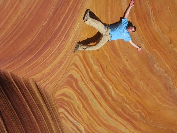
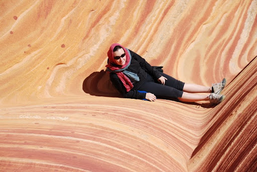
The soft sandstone of The Wave is fragile, one needs to walk carefully to not break the small ri dges.
dges.
A good time for photographing The Wave is the few hours around midday when there are no shadows in the center, although early morning and late afternoon shadows can also make for dramatic photos. After a recent rain storm, numerous pools form which can contain hundreds of tadpoles and fairy shrimp. These pools can be present for several days.
Above and slightly west of The Wave is the "Second Wave," which has fainter colors but is still of interest to most visitors and photographers. Hugo Martin from the Los Angeles Times said, "You can't call yourself a landscape photographer if you haven't snapped a photo or two of the Wave".
The Paria Canyon-Vermilion Cliffs Wilderness, which contains The Wave, is administered by the Bureau of Land Management (BLM). A permit from the BLM is required to visit The Wave.
The BLM limits access to the North Coyote Buttes Wilderness Area to just twenty permits per day. Ten of the permits are available in advance by an on-line lottery that is conducted four months before the month for which the permit is sought. The remaining ten permits are made available by lottery the day before one's intended hike at the Paria Ranger Station on highway 89 west of Page, Arizona. The lottery for the walk-in per mits takes place at 9:00 in the morning. Spring and autumn are the most popular times of year to visit, but the popularity of The Wave is such that the chances of obtaining a permit by either advance lottery or the day-before lottery are much less than 50% from March through November. The Wave is particularly well known among European tourists, partly because it appeared in Faszination Natur - Seven Seasons, a German documentary film made in the 1990s.
The trail begins at Wire Pass Trailhead, about 8.3 miles (13.4 km) south of US 89 along House Rock Valley Road, a dirt road about 35.4 miles (57.0 km) west of Page, Arizona or 38.6 miles (62.1 km) east of Kanab, Utah, that is accessible to most vehicles in good weather. During and after a storm the road may be impassable, even with a four-wheel-drive vehicle. Wire Pass Trailhead includes a wide parking lot with restrooms, but no water. It is also accessible from the Arizona side by taking U.S. Highway 89A from Jacob Lake on the Kaibab Plateau towards Navajo Bridge on turning north onto the House Rock Valley Road soon after descending from the Kaibab. This is a much longer access route over dirt road than fro m the Utah side.
From the Wire Pass Trailhead, The Wave can be reached by hiking approximately 3 miles (4.8 km) across open desert, making the round-trip to and from The Wave a nearly 6 miles (9.7 km) hike that climbs about 350 feet (110 m) in altitude. Temperatures in this area typically climb above 100 °F (38 °C) in the summer, so it is best to start the hike early. Anyone attempting the hike in any season is wise to be prepared for harsh desert conditions, including fierce winds, blowing sand, and little shade.
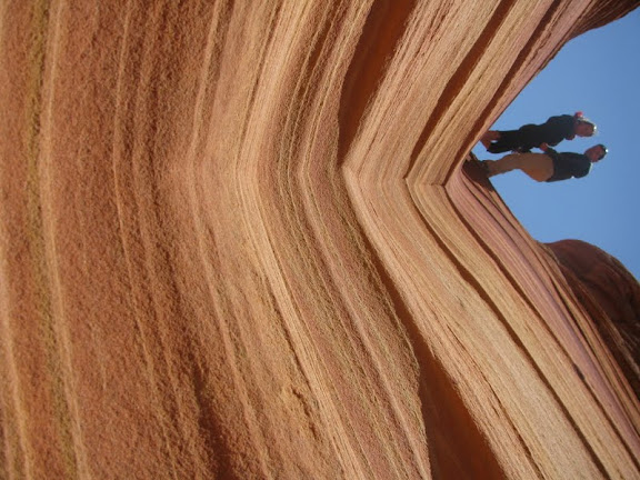
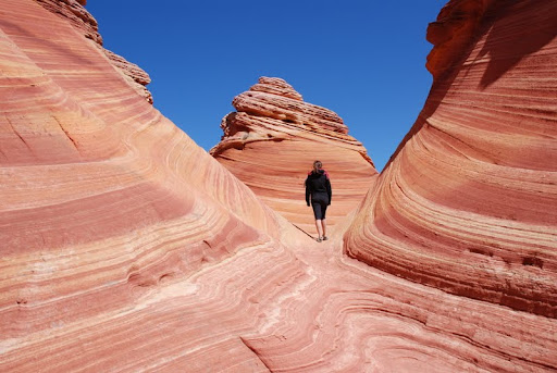
The Wave is challenging to find. In an effort to maintain the natural integrity of the region, there is no formal trail to The Wave. Most hikers are guided to The Wave either by GPS or a prominent landmark known as "the Black Crack," which is widely visible within the Coyote Buttes region. The Wave lies directly below the Black Crack. Hikers must choose their own route across the open desert, which requires traversing exposed sandstone, sand dunes, and sandy wash bottoms. It is not uncommon for hikers to get lost and never find The Wave.
A formal guide sheet for navigating to the Wave is now provided to every permitted hiker by the BLM. The guide is designed for use with compass, GPS, or visual navigation. The are six checkpoints each for the outbound hike to the Wave and the return to the trailhead. Each checkpoint includes a marked color photo of the terrain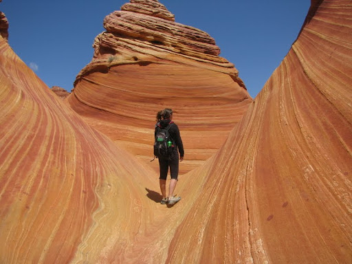 ahead, azimuth, latitude, longitude, UTM, northing, and easting. While less reliable, hikers may also observe many footprints in sandy areas and informal cairns on the slickrock. Visitors are well advised to closely study the guide sheet before starting their hike.
In past years there have been a significant number of Search and Rescue Operations conducted by both the Coconino County Sheriff's Office (Arizona) and the Kane County Sheriff's Office (Utah) for persons lost during the over-land hike to and from The Wave. Visitors are advised to take particular care in their navigation, carry a topographic map, compass and GPS and use them in the course of their excursions. The changing appearance of the terrain as the direction of the light shifts seems to be a important factor in a number of incidents. Any lost or missing persons should be reported immediately to either Sheriff's Office as the response time for SAR personnel to the area can be protracted. (It is best to call early and possibly have to cancel the response, rather than wait, which may cause the SAR operation to be conducted in the dark or after inclement weather moves in.)
MORE PICTURES
uttes, in the Paria Canyon-Vermilion Cliffs Wilderness, on the Colorado Plateau. It is famous among hikers and photographers for its colorful, undulating forms, and the rugged, trackless hike required to reach it.The Jurassic Navajo Sandstone Formation is the foundation of Coyote Buttes (and the Wave), Nearly 200 million years ago, this region was a sandy desert where huge dunes migrated across the landscape pushed by seasonal winds. Prevailing winds of that ancient Jurassic time can be determined by examining the cross-bedding (layers) in the sandstone. What we see today are some of the original crossbedded dunes shaped into dramatic landforms and exposed by erosion from eons of runoff. The spectacular ribbons of various colors called Liesegang Bands, were formed by movement and precipitation of oxidizing materials such as iron and manganese by ground water. Thin veins or fins of calcite cut across the sandstone, adding another dimension to the landscape. (Source: Bureau of Land Management display at the Wave trailhead.)
The soft sandstone of The Wave is fragile, one needs to walk carefully to not break the small ri
dges.A good time for photographing The Wave is the few hours around midday when there are no shadows in the center, although early morning and late afternoon shadows can also make for dramatic photos. After a recent rain storm, numerous pools form which can contain hundreds of tadpoles and fairy shrimp. These pools can be present for several days.
Above and slightly west of The Wave is the "Second Wave," which has fainter colors but is still of interest to most visitors and photographers. Hugo Martin from the Los Angeles Times said, "You can't call yourself a landscape photographer if you haven't snapped a photo or two of the Wave".
The Paria Canyon-Vermilion Cliffs Wilderness, which contains The Wave, is administered by the Bureau of Land Management (BLM). A permit from the BLM is required to visit The Wave.
The BLM limits access to the North Coyote Buttes Wilderness Area to just twenty permits per day. Ten of the permits are available in advance by an on-line lottery that is conducted four months before the month for which the permit is sought. The remaining ten permits are made available by lottery the day before one's intended hike at the Paria Ranger Station on highway 89 west of Page, Arizona. The lottery for the walk-in per
mits takes place at 9:00 in the morning. Spring and autumn are the most popular times of year to visit, but the popularity of The Wave is such that the chances of obtaining a permit by either advance lottery or the day-before lottery are much less than 50% from March through November. The Wave is particularly well known among European tourists, partly because it appeared in Faszination Natur - Seven Seasons, a German documentary film made in the 1990s.The trail begins at Wire Pass Trailhead, about 8.3 miles (13.4 km) south of US 89 along House Rock Valley Road, a dirt road about 35.4 miles (57.0 km) west of Page, Arizona or 38.6 miles (62.1 km) east of Kanab, Utah, that is accessible to most vehicles in good weather. During and after a storm the road may be impassable, even with a four-wheel-drive vehicle. Wire Pass Trailhead includes a wide parking lot with restrooms, but no water. It is also accessible from the Arizona side by taking U.S. Highway 89A from Jacob Lake on the Kaibab Plateau towards Navajo Bridge on turning north onto the House Rock Valley Road soon after descending from the Kaibab. This is a much longer access route over dirt road than fro
m the Utah side.From the Wire Pass Trailhead, The Wave can be reached by hiking approximately 3 miles (4.8 km) across open desert, making the round-trip to and from The Wave a nearly 6 miles (9.7 km) hike that climbs about 350 feet (110 m) in altitude. Temperatures in this area typically climb above 100 °F (38 °C) in the summer, so it is best to start the hike early. Anyone attempting the hike in any season is wise to be prepared for harsh desert conditions, including fierce winds, blowing sand, and little shade.
The Wave is challenging to find. In an effort to maintain the natural integrity of the region, there is no formal trail to The Wave. Most hikers are guided to The Wave either by GPS or a prominent landmark known as "the Black Crack," which is widely visible within the Coyote Buttes region. The Wave lies directly below the Black Crack. Hikers must choose their own route across the open desert, which requires traversing exposed sandstone, sand dunes, and sandy wash bottoms. It is not uncommon for hikers to get lost and never find The Wave.
A formal guide sheet for navigating to the Wave is now provided to every permitted hiker by the BLM. The guide is designed for use with compass, GPS, or visual navigation. The are six checkpoints each for the outbound hike to the Wave and the return to the trailhead. Each checkpoint includes a marked color photo of the terrain
ahead, azimuth, latitude, longitude, UTM, northing, and easting. While less reliable, hikers may also observe many footprints in sandy areas and informal cairns on the slickrock. Visitors are well advised to closely study the guide sheet before starting their hike.In past years there have been a significant number of Search and Rescue Operations conducted by both the Coconino County Sheriff's Office (Arizona) and the Kane County Sheriff's Office (Utah) for persons lost during the over-land hike to and from The Wave. Visitors are advised to take particular care in their navigation, carry a topographic map, compass and GPS and use them in the course of their excursions. The changing appearance of the terrain as the direction of the light shifts seems to be a important factor in a number of incidents. Any lost or missing persons should be reported immediately to either Sheriff's Office as the response time for SAR personnel to the area can be protracted. (It is best to call early and possibly have to cancel the response, rather than wait, which may cause the SAR operation to be conducted in the dark or after inclement weather moves in.)
MORE PICTURES
 |  |  |  |  |  |  |  |  |  |  |  |  |
 |  |
 |  |  |  |  |  |  |  |
 |  |  |  |  |  |  |  |
 |  |
You have read this article with the title THE WAVE, ARIZONA. You can bookmark this page URL http://tiogatalk.blogspot.com/2011/07/the-wave-arizona.html. Thanks!
Write by:
AN - Wednesday, July 27, 2011


Comments "THE WAVE, ARIZONA"
Post a Comment