
Satellite image of Switzerland . On the north side of the Alps, the regions located above 2000 m are covered by snow. The canton of Ticino (on the south side) is almost snow-free in early autumn
The Swiss Alps (German: Schweizer Alpen, French: Alpes suisses, Italian: Alpi svizzere, Romansh: Alps svizras) are the portion of the Alps mountain range that lies within Switzerland. Because of their central position within the entire Alpine range, they are also known as the Central Alps. The highest summit in the Swiss Alps is Monte Rosa (4,634 metres (15,202 ft)) near the Swiss-Italian border. The highest mountain which lies entirely on Swiss territory is the Dom (4,545 metres (14,911 ft)). Other main summits can be found in the list of mountains in Switzerland.

Swiss Alps seen from the Swiss Jura
Since the Middle Ages, transit across the Alps played an important role in history. The region north of the St. Gotthard Pass became the nucleus of the Swiss Confederacy in the early 14th century.

Rhine Gorge in Graubünden
Rivers
Rhine Gorge in GraubündenThe north side of the Swiss Alps is drained by the Rhone, Rhine and Inn river (which is part of the Danube basin) while the south side is mainly drained by the Ticino river (Po basin). The rivers on the north empty into the Mediterranean, North and Black Sea, on the south the Po empty in the Adriatic Sea. The major triple watersheds in the Alps are located within the country, they are: Piz Lunghin, Witenwasserenstock and Monte Forcola. Between the Witenwasserenstock and Piz Lunghin runs the European Watershed separating the basin of the Atlantic (North Sea) and the Mediterranean Sea (Adriatic and Black Sea). The European watershed lies in fact only partially on the main chain. Switzerland possesses 6% of Europe's fresh water, and is sometimes referred to as the "water tower of Europe".
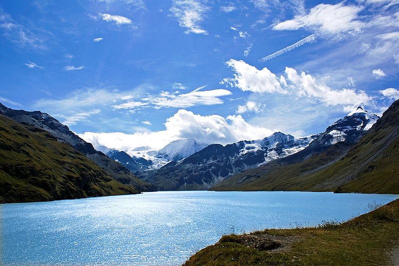
The Lac des Dix in Valais
Lakes
The Lac des Dix in ValaisSince the highest dams are located in Alpine regions, many large mountain lakes are artificial and are used as hydroelectric reservoirs. Some large artificial lakes can be found above 2,300 m, but natural lakes larger than 1 km² are generally below 1,000 m (with the exceptions of lakes in the Engadin such as Lake Sils, and Oeschinen in the Bernese Oberland). The melting of low-altitude glaciers can generate new lakes, such as the 0.25 km² large Triftsee which formed between 2002–2003.

Lauterbrunnental Valley in the Bernese Alps, a U-shaped valley that resulted from the erosion of glaciers
Climate zones
As the temperature decreases with altitude (0,56°C per 100 metres on yearly average), three different altitudinal zones, each having distinct climate, are found in the Swiss Alps:

Tree line in the National park
l Subalpine zone
The Subalpine zone is the region which lies below the tree line. It is the most important region as it is the larger of the three and contains almost all human settlements as well as the productive areas. The forests are mainly composed by conifers above 1,200-1,400 metres, the deciduous tree forest being confined to lower elevations. The upper limit of the Subalpine zone is located at about 1,800 metres on the north side of the Alps and at about 2,000 metres on the south side. It can however differ in some regions such as the Appenzell Alps (1,600 metres) or the Engadin valley (2,300 metres).
Lyskamm (4,527 m), above the Grenz Glacier
l Alpine zone
The Alpine zone is situated above the tree line and is clear of trees because of low average temperatures. It contains mostly grass and small plants along with mountain flowers. Below the permafrost limit (at about 2,600 metres), the alpine meadows are often used as pastures. Some villages can still be found on the lowest altitudes such as Riederalp (1,940 m) or Juf (2,130 m). The extend of Alpine zone is limited by the first permanent snow, its altitude greatly vary depending on the location (and orientation), it is comprised between 2,800 and 3,200 metres.

Glacier 3000
l Glacial zone
The glacial zone is the area of permanent snow and ice. When the steepness of the slope is not too high it results in an accumulation and compaction of snow, which transforms into ice. The glacier formed then flows down the valley and can reach as far down as 1,500 metres (the Upper Grindelwald Glacier). Where the slopes are too steep, the snow accumulates to form overhanging seracs, which periodically fall off due to the downwards movement of the glacier and cause ice avalanches. The Bernese Alps, Pennine Alps and Mont Blanc Massif contain most of the glaciated areas in the Alps. Except research stations such as the Sphinx Observatory no settlements are to be found in those regions.

Highest ski area in Europe above Zermatt
Travel and tourism
Tourism in the Swiss Alps began with the first ascents of the main peaks of the Alps (Jungfrau in 1811, Piz Bernina in 1850, Monte Rosa in 1855, Matterhorn in 1856, Dom in 1858, Weisshorn in 1861) mostly by British mountain climbers accompanied by the local guides. The construction of facilities for tourists started in the mid nineteenth century with the building of hotels and mountain huts (creation of the Swiss Alpine Club in 1863) and the opening of mountain train lines (Mount Rigi in 1873, Mount Pilatus in 1889, Gornergrat in 1898). The Jungfraubahn opened in 1912; it leads to the highest train station in Europe, the Jungfraujoch.

Thanks to a car-free policy, Zermatt retains much of its original character
Summer tourism
Switzerland enjoys a 62,000-km network of well-maintained trails, of which 23,000 are located in mountainous areas. Many mountains attract a large number of alpinists from around the world, especially the 4000-metre summits and the great north faces. The large winter resorts are also popular destinations in summer, as most of aerial tramways operate through the year, enabling hikers and mountaineers to reach high altitudes without much effort. The Klein Matterhorn is the highest summit of the European continent to be served by cable car.

The Glacier Express on the Landwasser Viaduct, Albula Range
Winter tourism
The major destinations for skiing and other winter sports are located in Valais, Bernese Oberland and Graubünden. Some villages are car-free and can be accessed only with public transports such as Riederalp and Bettmeralp. Zermatt and Saas-Fee have both summer ski areas. The most visited places are:
l Davos - Klosters
l Zermatt (car-free village)
l St. Moritz
l Grindelwald - Mürren - Wengen (car-free villages)
l Adelboden - Lenk
l Verbier - Nendaz
l Gstaad
l Flims - Laax
l Lenzerheide - Arosa
l Crans Montana
Other important destinations on the regional level are Engelberg and Andermatt (Central Switzerland), Leysin (Vaud), Champéry (western Valais) and Samnaun

Lötschberg line
Transportation
The Swiss Alps and Switzerland enjoy an extensive transportation network. Every mountain village can be reached by public transport, the main companies are:
l Federal Railway
l Rhaetian Railway
l Matterhorn Gotthard Bahn
l Golden Pass
l PostBus

Most of mountain regions are within 3 hours travel of Switzerland’s main cities and their respective airport. The Engadin Valley in Graubünden is between 4 to 6 hours away from the large cities; the train journey itself, with the panoramic Glacier Express or Bernina Express, is popular with tourists.
The Engadin Airport near St. Moritz at an altitude of 1,707 metres (5,600 ft) is the highest in Europe.

The Aiguille d'Argentière above the Saleina Glacier, Mont Blanc Massif
The crossing of the Alps is a key issue at national and international levels, as the European continent is at places divided by the range. Since the beginnings of industrialization Switzerland has improved its transalpine network; it began in 1882, by building the Gotthard Rail Tunnel, followed in 1906 by the Simplon Tunnel and more recently, in 2007, by the Lötschberg Base Tunnel. The 57-km long Gotthard Base Tunnel is slated to be open in 2016, and it will finally provide a direct flat rail link through the Alps.

Finsteraarhorn, Bernese Alps

The Grand Combin, Pennine Alps

The Matterhorn, Pennine Alps

Morteratsch Glacier and Piz Bernina

Eiger, Mönch and Jungfrau, Bernese Alps

Oberaar Glacier, Bernese Alps

Piz Badile, Bregaglia Range

Stein Glacier from Susten Pass, Urner Alps

The Dent Blanche, Pennine Alps

Piz Roseg and Val Roseg, Bernina Range

The Weissmies from Hohsaas, Pennine Alps

Bachalpsee, Bernese Alps

Jungfraujoch, Bernese Alps

Summits around the Mattertal, Pennine Alps
You have read this articleSwitzerland
with the title Swiss Alps. You can bookmark this page URL http://tiogatalk.blogspot.com/2014/10/swiss-alps.html. Thanks!
Write by:
AN - Tuesday, October 21, 2014


Comments "Swiss Alps"
Post a Comment